Tratamiento taxonómico
Luzula gigantea Desv., J. Bot. (Desvaux) 1: 145. 1808.
Type: Colombia. Quindío: “in montibus Quindío in regno Santafe de Bogota”, A. von Humboldt & A. J. Bonpland s.n. (holotype P). Figs. 20, 21
Perennial herbs, 20-90 cm high. Rhizome ascending, 1.5 3 mm diameter, often covered with wilted leaves and giving rise to ascending runners terminated by leaf rosettes. Culms erect, terete, 2-4 mm diameter. Basal leaves up to 25 in a rosette; sheaths short; blade bending away from the culm, linear to narrowly lanceolate, (5-)10-20 mm wide, flat, margin hairy in young leaves. Cauline leaves resembling basal ones, but sheath to 6 cm long, and the blade shorter and more erect. Inflorescence a loose, much branched panicle constituting more than 1/3 of the total plant height, storied and subdivided by 5-15 cm long rachis segments into 4- 5 subequal, nodding parts, one above the other, the flowers inserted individually on distinct pedicels; bracts of primary inflorescence branches resembling cauline leaves, proximal ones to 20 cm long, distal ones progressively smaller; bracteoles and distal bracts in the inflorescence linear to lanceolate, membranous, margin entire or divided into ciliate lobes. Tepals unequal, light brown to dark castaneous, outer ones 2-3(-3.5) mm long, inner ones 1.5-2.5 mm long, narrower. Stamens six, 1-1.5 mm long; anthers oblong, 0.3-0.6 mm long. Capsule broadly ellipsoid, apiculate, 1.3-2 x 0.8-1.6 mm, light green at first, castaneous and glossy at maturity. Seeds ellipsoid to oblong, broadly apiculate, 0.9-1.3 x 0.4 0.6 mm, smooth to rugose, inner seed coat castaneous, outer seed coat white to light brown.
Distribution and habitat. L. gigantea is distributed in the Andes from Venezuela to N Argentina at elevations of 2650 -4500 m above sea level, but most commonly at 3000 4000 m. In Colombia it is widely distributed along Andes and the Sierra Nevada de Santa Marta, between 2660 and 4500 m.
Comments. L. gigantea is easily recognized by its individually inserted flowers and broad, long leaves. It is also distinct because of its long rachis segments that subdivide the inflorescence in 4-5 subequal nodding parts, one above the other.
Representative specimens. Antioquia: páramo de Frontino, río Urrao, 3200 m, 11 Mar 1944, Core 415, lf (NY, US); Urrao, páramo de Frontino, 3600-3800 m, 19 Jul 1995, D. Sánchez 2225 (COL). Boyacá: nevado del Cocuy, Chorreón de San Paulino, 3750 m, 10 Sep 1938, Cuatrecasas 1367, fl, fr (COL, F, US); páramo de Pisba, carretera Socha-La Punta, km 70, 3530 m, 16 Jun 1972, Cleef 4621, fl (COL); municipio Cocuy, cañón del Chicamocha, 3500 m, 22 May 1991, Etter 478 (COL); Sierra Nevada del Cocuy, quebrada de las Playas, 4100 m, 7 Aug 1957, Grubb 321, fl (K, US); municipio Güicán, Sierra Nevada del Cocuy, laguna Grande de Los Verdes, 3900-4100 m, 20 Sep 1978, Rangel-Ch. 1567, fl (COL). Caldas: Guadalupe, 2900 m, Jul 1912, Brother ApolinarMaría120 fl (US); nevado del Ruiz, entre Termales, Nevado y Líbano, 4050-4100 m, 17 Dec 1958, H. G. Barclay 6398, fl, fr (COL, US); páramo del Quindío, 4100-4300 m, 15-22 Aug 1922, Pennell 9885, fl (US); páramo del Quindío, 4300-4500 m, 15-20 Aug 1922, Pennell 9900, fl (GH, NY, US), nevados del Ruiz y de Santa Isabel, 4140-4300 m, 9 Oct 19, Rangel-Ch. 1796, (COL). Cauca: municipio Puracé, N slope volcán Puracé, 2700-2800 m, 23 Jul 1956, H. G. Barclay 156, fl, fr (COL, GH); Chapa-río Blanco, 3000 m, 13 Jul 1944, Core 908, fr (GH, US); páramo Las Moras, 3700-3800 m, 19 Feb 1969, Cuatrecasas 27430, fl (COL, US); La Plata road from Puracé to Alto de San Rafael, 2660 3450 m, 21 Jul 1948, García-Barriga 12828, fl, fr (COL, US); páramo de Guanacas, Popayán, 2800-3300 m, no date, Lehmann 5258, fl, fr (F,US). Cesar: Sierra de Perija, E of Manaure, 3000-3100 m, 7 Nov 1959, Cuatrecasas 25089, fr (COL, US); serranía del Perija, municipio Manaure, cerro El Avión, 3400 m, 6 Nov 1993, Rangel-Ch. 11153 (COL).; municipio de La paz, Serrania Perija, base del Cerro El Avion, 3200-3600 m, 3 Mar 1959, Romero-Castañeda 7365, fr (COL). Chocó: municipio de Nóvita, macizo de Tatamá, pico Belisario, 4100 m, 19 Feb 1983, Torres-R. 2443, fl (COL). Cundinamarca: Bogotá, corregimiento Santa Rosa, entre Chisacá y la casa del PNN Sumapaz, 6 Sep 1999, Betancur 8176 (COL); páramo de Sumapaz, laguna Gobernador, 3835 m, 26 Jan 1973, Cleef 8310B, st (COL); macizo de Bogotá, La Calera, páramo de Palacio, hacienda la Siberia, 3420-3500 m, 11 Dec 1959, Cuatrecasas 25591, fr (COL, US); S of Usme between La Regadera and El Hato, 3000-3100 m, 15 Jun 1950, Idrobo 385 fl (COL, US); Los Gaques, W slope of páramo de Guasca, Los Gaques, 3250 m, 12 Mar 1939, Killip 34162, fl, fr, (COL, US). Magdalena: Sierra Nevada de Santa Marta, río Sevilla, 3100 m, 22 Jan 1959, H. G. Barclay 6614, fr (COL, MO, US); Sierra Nevada de Santa Marta, Alto Buritica, 3300 m, 9 Aug 1977, Jaramillo-Mejía 5501, fl (COL). Meta: páramo de Sumapaz, Hoya Sitiales, laguna La Primavera, 3580 m, 25 Jan 1972, Cleef 992, fl (COL, U); páramo de Sumapaz, cerro nevado de Sumapaz, 3600-4100 m, Cleef 8092, fl (COL); macizo de Sumapaz, Cerro Nevado, 4100-4350 m, 6 Jun 1981, Díaz-Piedrahita 2572, fl (COL); macizo de Sumapaz, quebrada El Buque, 3400 m, 11-12 Jun 1981, DíazPiedrahita 2780, fl (COL); Cubarral, laguna de La Guitarra, páramo de Sumapaz, 3420 m, 11 Jun 1981, Franco-Roselli 324, fl (COL). Nariño: Galeras near Pasto, 18 Jul 1957, H. G. Barclay 4616, fr (COL); páramo del Tábano between Pasto and El Encano, 3200 m, 11 Jan 1941, Cuatrecasas 11896, fl (COL, F, US); volcán Galeras near Pasto, 3900 4000 m, 11 Jan 1981, Gentry 30519, lf (COL, MO, NY); mountain Galeras, 4000 m, 22 Oct 1968, Plowman 1965, fl (COL, GH, K, S, US); municipio Cumbal, volcán nevado del Cumbal, vereda las Vuertas, 4000 m, 5-9 Mar 1999, Stancik 2718 (COL, PSO). Norte de Santander: páramo de Tama, La Cueva, 3000-3200 m, 28 Oct 1941, Cuatrecasas 12717, fl (COL, F, US). Putumayo: páramo el Palomo, 26 May 1935, García-Barriga 4644, fl, fr (COL, US); laguna La Cocha, 3200 m, 12 Jan 1952, Knoth 3357, fr (COL). Quíndio: boquerón del Quindío, 10 Mar 1876, André 2244 (NY). Risaralda: municipio de Santa Rosa, hacienda La Sierra, valle de la quebrada Betania, 25 Jan 1980, Jaramillo-Mejía 5887, fr (COL). Tolima: La Línea-cerro El Campanario, 3400-3580 m, 4 Mar 1969, Cuatrecasas 27697, fl, fr (COL, US); Florida-Herrera road top of Cordillera Central, 3600 m, 16 Nov 1944, Core 1590, fl (F, UC, US); Along Divide near Quindío Highway, 3300 3500 m, 27 Mar 1939, Killip 34605, fl (COL, US); páramo de Ruiz, Rosalito, 2900-3200 m, 15-17 Dec 1917, Pennell 3105, fl (GH, NY, US). Locality unknown: páramo del Ruiz, 4000 m, 30 Aug 1957, H. G. Barclay 5279, fl (COL).
Figuras
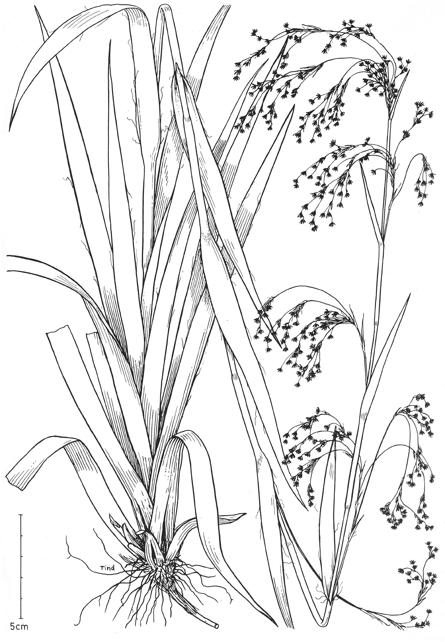
Figure 20. Luzula gigantea. Note wide leaves, storied inforescence, singly inserted fowers (Fagerlind 1405b, S). Published in Flora of Ecuador 11: 1-45, 1979, and Flora Neotropica 68:1- 167, 1996.
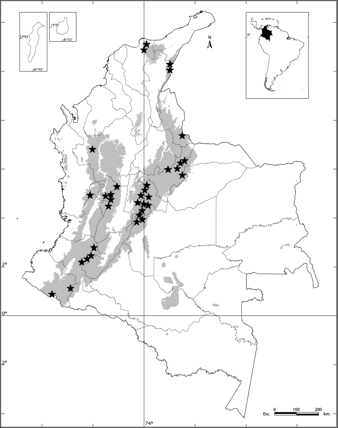
Figure 21. Geographic distribution of Luzula. gigantea (*).
Relacionados